








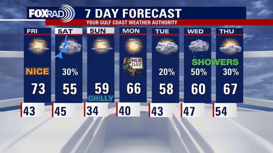
Houston is set for a brief warm-up on Friday, with temperatures expected to reach the low 70s before a cold front moves in.
The day will begin cool, though not as chilly as Thursday morning. As the afternoon approaches, residents can anticipate a pleasant rise in temperatures, peaking in the low 70s. However, the arrival of another cold front in the early evening will bring back cloud cover.
On Saturday, as the front traverses Texas, there is a slight chance of isolated showers. Weather models are showing mixed signals, indicating that while showers are possible, confidence in their occurrence is low. Expect increased cloudiness and a chance for rain, particularly in the morning hours.
Following this system, a significant drop in temperatures will occur, leading to a brisk Sunday morning with lows expected to dip into the 30s. Throughout the day, temperatures will remain cool, hovering in the 50s, just in time for Texans watch parties.
Looking ahead, the prolonged dry spell affecting much of the region, which has contributed to a severe drought, may finally come to an end by mid-next week. Weather forecasts suggest that a more substantial weather system could arrive between Tuesday and Thursday, offering the highest likelihood of widespread rain seen in the past week.