








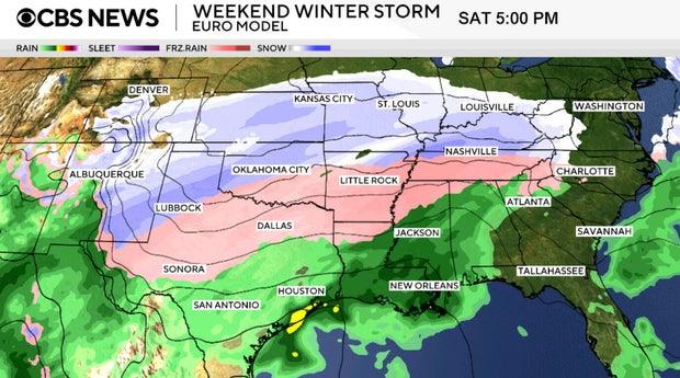
Over 200 million people in the United States are bracing for a significant winter storm expected to unleash a combination of heavy snow, ice, and severe cold across a 2,000-mile stretch of the country this weekend. This storm is projected to be the largest of its kind in five years, potentially impacting about two-thirds of the nation.
The storm’s effects began on Friday in the Southern Plains, where freezing rain and snow were already reported. As the system progresses, it is forecasted to move into the Mississippi and Tennessee Valleys on Saturday, eventually reaching the Northeast and Mid-Atlantic regions by Sunday into Monday.
This slow-moving weather system raises concerns for prolonged periods of snowfall and ice accumulation. Winter weather alerts have been issued from the Southern Plains all the way to the Northeast, affecting at least 185 million people. Seventeen states, along with Washington, D.C., are currently under states of emergency, and nine states have mobilized National Guard troops in preparation.
Extreme cold is another pressing issue, with temperatures in the Minneapolis area plummeting to 21 degrees below zero on Friday morning, coupled with dangerously low wind chills. Throughout the weekend, record low temperatures are anticipated across parts of the Southern Plains and Mid-Atlantic.
Forecasted Snow and Ice Accumulation
A low-pressure system originating in the Southwest is on track to combine with moisture from the Gulf and Arctic air, initiating precipitation in the Southern Plains. Meteorologists predict that the system will gradually push eastward, leading to significant snowfall and ice accumulation.
Heavy snowfall is expected across a wide band of the country, with areas like the Texas Panhandle and the Ozarks potentially receiving over a foot of snow. The central Appalachians and parts of the Northeast could see snowfall totals nearing two feet, according to meteorologists from the National Weather Service.
In New York, some regions might experience snow accumulations ranging from 6 to 12 inches. Meanwhile, the polar vortex, typically positioned over the North Pole, is dipping southward, contributing to the chilling temperatures expected to persist through the early part of next week.
Travel Disruptions Ahead
Travel plans are likely to be adversely affected by the impending weather. Airports in the South may face significant challenges due to a lack of deicing equipment, resulting in numerous flight cancellations and delays. Major airports such as Dallas Fort Worth International, Will Rogers International in Oklahoma City, and Hartsfield-Jackson Atlanta International are among those anticipated to be impacted.
In response, major airlines are issuing travel waivers and alerts, allowing passengers to modify their travel plans without incurring penalties. American Airlines is adding extra flights around Dallas Fort Worth International Airport to accommodate travelers, while Delta Air Lines has indicated that cancellations will be necessary at select airports in the affected regions.
Road conditions are expected to be treacherous, particularly on major interstates. Authorities strongly advise against travel throughout the weekend, but if necessary, drivers are urged to exercise extreme caution.
Preparations in Progress
Preparedness efforts are underway, with around 18,000 utility workers positioned in the Carolinas to manage potential power outages. The Oklahoma National Guard is on standby to assist stranded motorists, and New York City has mobilized salt trucks and sanitation workers to clear streets in anticipation of the storm.
In Texas, officials are working diligently to ensure that the state’s power grid remains stable during the storm, following widespread outages from a previous ice storm in 2021. Stores across the South are experiencing a surge in customers stocking up on essential items, while medical facilities are bracing for an influx of cold-related injuries.
Uncertainty in Forecasts
While initial forecasts exhibited considerable variation, confidence is increasing as the storm approaches. Meteorologists noted that discrepancies among models are typical several days prior to a storm’s arrival, especially with winter weather, where slight temperature changes can significantly alter precipitation types.
As the situation develops, residents are advised to stay informed and prepared for the winter storm’s impact.