








A severe cold front continues to grip the eastern United States as meteorologists monitor another potential winter storm set to impact the East Coast this weekend. This follows a powerful weather system that recently blanketed vast areas of the country in snow and ice, resulting in numerous fatalities. The aftermath of that storm still affects many regions, with Arctic air from Canada contributing to a prolonged period of sub-freezing temperatures.
According to the National Weather Service, this situation could lead to one of the longest stretches of cold weather the Eastern and Southeastern U.S. have faced in decades. A new wave of frigid air is expected to accompany a storm developing off the Carolinas, although its exact trajectory remains uncertain. Meteorologists suggest it will likely influence coastal regions and parts of the surrounding mid-Atlantic states.
Potential Storm Development
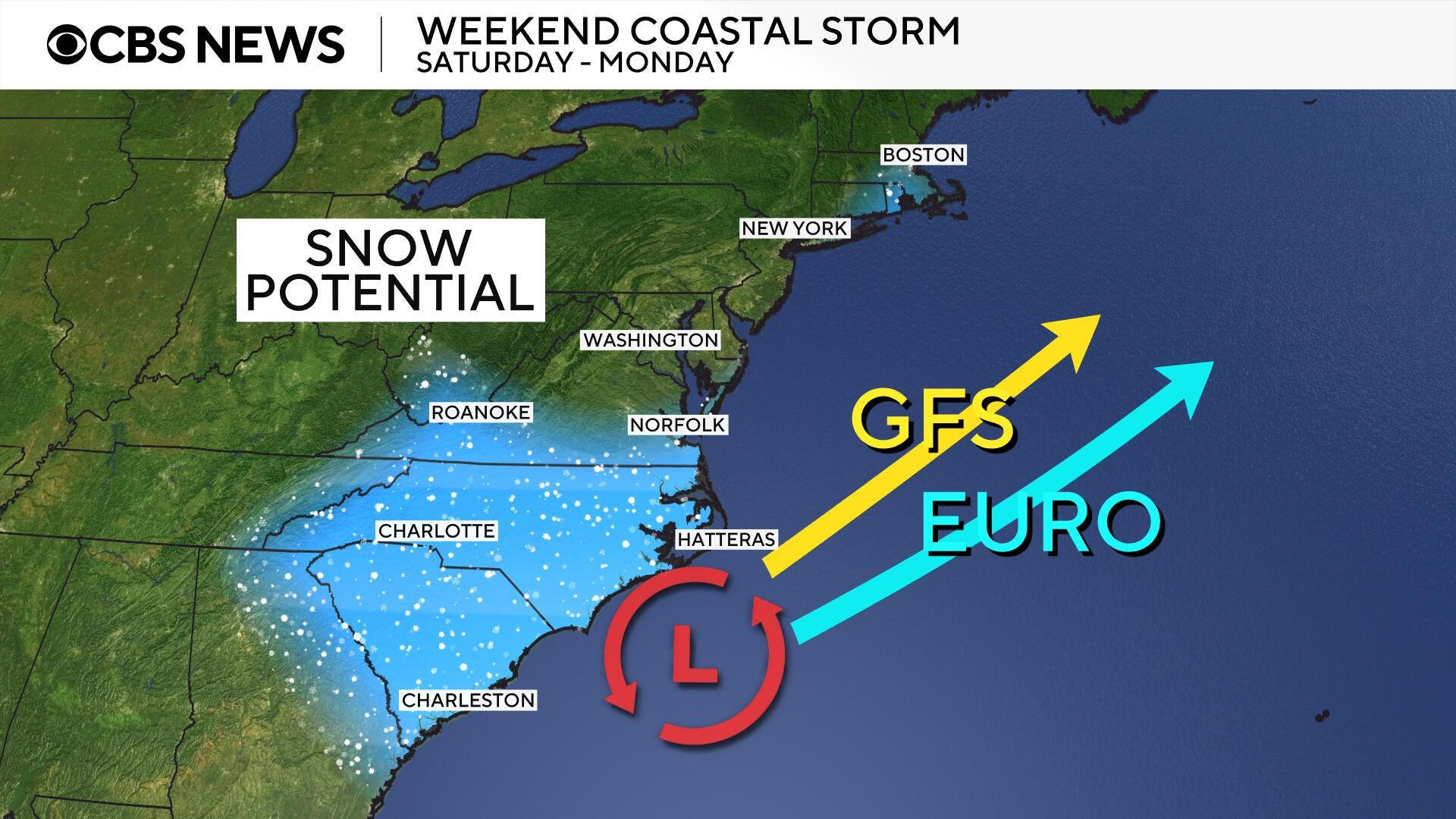
A low-pressure system appears to be forming off the Carolina coast, which could set the stage for another winter storm this weekend. Forecast models show varied paths for the storm after it turns northward; some indicate a slight eastward shift, while others suggest a westward tilt. The former scenario could allow the storm to bypass land, while the latter could bring wintry weather, including snow, to portions of the Northeast.
The projected path of the storm will significantly determine its impact on the East Coast. Meteorologists are increasingly confident that southern Mid-Atlantic states, the Carolinas, and Southern Appalachia will experience snowfall, but predictions remain less certain for areas further north.
“There is still some uncertainty regarding the storm’s trajectory,” noted Allison Santorelli, a meteorologist with the National Weather Service’s Weather Prediction Center. “However, we are confident in expecting a significant winter storm for the Southern Appalachians and southern Mid-Atlantic, while confidence decreases moving toward New England, depending on the storm track.”
Regardless of the specific path taken, Santorelli emphasized that “significant impacts” are anticipated for many areas along the East Coast this weekend, including strong winds. The National Weather Service issued a warning that the storm “will generate powerful onshore winds from the North Carolina Outer Banks northward,” with gusts potentially strong enough to cause coastal flooding.
Warnings and Preparations
Winter storm warnings and watches have been issued for parts of the Carolinas, Georgia, Illinois, Massachusetts, Tennessee, Virginia, and West Virginia, with most advisories in effect until Sunday. In Virginia and the Carolinas, where the storm’s impact is expected to be most severe, forecasters predict blizzard conditions that could severely reduce visibility and make travel hazardous, with some areas possibly receiving up to 16 inches of snow.
Additionally, dangerous wind gusts are anticipated, with some approaching hurricane-force speeds. The National Weather Service office in Newport, North Carolina, has warned residents to prepare for gusts reaching up to 65 mph.
Record-Breaking Cold Temperatures
An incoming surge of Arctic air will keep temperatures well below freezing, creating conditions favorable for snow accumulation on roads and surfaces. On Friday morning, several eastern cities, including Baltimore, Buffalo, New York City, Philadelphia, and Pittsburgh, are projected to experience record-low temperatures.
For instance, forecasts for New York’s LaGuardia Airport predict temperatures dropping to 4 degrees Fahrenheit, which would tie a record set nearly 80 years ago in 1948. A similar situation is expected in Newark, New Jersey, where temperatures could dip to 3 degrees, matching a record from 1935. Inland areas may see even colder conditions, with predictions of -8 degrees in Pittsburgh and -5 degrees in Buffalo, both of which would break records established in 2019.
The developing storm off the Carolina coast will exacerbate the already severe wind chills, plunging temperatures well below zero across the eastern U.S. and parts of the South, where many regions are still dealing with ongoing power outages from the previous weekend.
Possibility of a Bomb Cyclone
Despite discrepancies in storm forecasts, meteorologists are considering the chance that a “bomb cyclone” could emerge if the storm intensifies rapidly. According to forecasters, the conditions expected this weekend could favor this phenomenon, also known as bombogenesis, which involves a winter storm undergoing swift intensification, although its occurrence is not guaranteed.
Santorelli indicated that the likelihood of the storm being classified as a bomb cyclone while moving up the coast is increasing based on the latest models. She added that such rapid intensification is more probable if the storm tracks farther from the coast, minimizing its interaction with land as it progresses northward.