







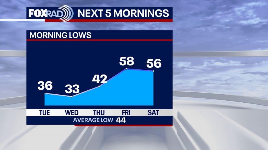
As the week begins, Houston is bracing for a significant cold front accompanied by a wind advisory. A dramatic drop in temperatures has been noted, with readings falling into the 50s by Monday morning. Expect even colder conditions with temperatures dipping into the 30s on Tuesday and Wednesday mornings, exacerbated by lower wind chill values.
In a remarkable turn of events, the area experienced record-high temperatures over the weekend, reaching 83 degrees on Saturday and breaking a previous record of 82 degrees set in 2021 with a high of 84 degrees at Bush Intercontinental Airport. However, this warmth has quickly been replaced by the cold front, leading to the current chill.
A wind advisory remains in effect until 6 p.m. today, with wind speeds currently ranging from 10 to 20 mph and gusts reaching between 25 and 45 mph. The arrival of this cold front has also resulted in a decrease in humidity, creating dry conditions that raise the risk of wildfires across much of Southeast Texas. Although some counties have recently lifted their burn bans due to improved drought conditions, it is advisable to refrain from any outdoor activities that could ignite a fire today.
Looking ahead to New Year’s Eve, the weather is expected to stabilize into a cool and calm pattern. Daytime temperatures will hover in the upper 50s, with nighttime lows dropping into the 40s—ideal for outdoor festivities, provided you bundle up in a warm jacket. As midnight approaches, temperatures will be in the upper 40s. New Year’s Day promises to be dry and pleasant, with highs nearing 70 degrees, setting the stage for a warm start to 2026.