









Residents of North Texas are urged to remain vigilant as the region prepares for a multi-day severe weather event, prompting Governor Greg Abbott to activate state emergency resources. The potential for tornadoes and large hail looms through Sunday, with storm activity expected to intensify beginning Saturday evening.
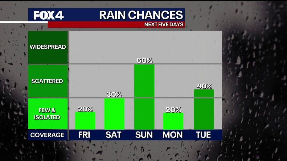
Despite a relatively calm Friday, with temperatures reaching the low 80s and mostly dry conditions, isolated storms capable of producing small hail may develop, particularly south of the Dallas-Fort Worth area. The National Weather Service has issued warnings that unsettled weather will persist into the week, creating an environment conducive to strong storms each afternoon and evening.
Governor’s Response to Severe Weather Threat
In light of the impending severe weather, Governor Abbott has instructed the Texas Division of Emergency Management (TDEM) to mobilize state emergency response resources. These preparations aim to bolster local authorities as they brace for the potential impact of severe weather across North, West, and Central Texas through early next week.
The resources on standby include swiftwater rescue teams, urban search and rescue units, and ambulances. Additionally, all-terrain vehicles and helicopters will be available for water rescues. State officials are also closely monitoring wildfire conditions in West and Northwest Texas, where dry weather and high winds could pose additional risks.
“The State of Texas stands ready to deploy all necessary resources to help local officials respond to potential severe weather,” Abbott stated. He advised residents to stay informed about road conditions, create emergency plans, and follow the guidance of local authorities.
Upcoming Weather Forecast
As the weekend approaches, storm chances will rise. By Saturday afternoon, scattered storms may develop west of the Metroplex, with a more organized storm system expected to move in Saturday night into early Sunday. This will bring rain, lightning, and a potential for damaging winds.
Sunday is anticipated to be the most concerning day, with the National Weather Service indicating a significant severe storm threat could emerge in the afternoon, particularly if morning cloud cover dissipates swiftly. This could lead to a volatile atmosphere, heightening the likelihood of severe weather, including large hail and tornadoes.
Looking Ahead
Weather patterns are expected to remain active through at least Wednesday. Meteorologists note that while the specific timing and coverage of storms may vary, conditions will continue to be favorable for strong to severe storms during the afternoons and overnight hours next week. A brief pause in storm activity may occur on Monday, but a heightened risk for severe weather is anticipated to return on Tuesday and Wednesday.