








KERR COUNTY — A year after devastating floods claimed more than 100 lives along the Guadalupe River, Central and South Texas faced another round of deadly flooding in July, prompting flash flood emergencies that led to evacuations and rescues across the region.
While the two flooding events in July shared similarities in intensity and impact, they occurred in distinctly different manners — last year’s flooding was characterized by a swift, concentrated downpour, whereas this year’s event involved multiple days of heavy rainfall across a wide area.
Weather officials indicated that their warning strategies remained consistent, but residents and first responders reported having improved resources and a heightened sense of urgency stemming from the previous year’s tragedy. This awareness contributed to a significantly lower death toll amid the widespread flooding.
“It’s still fresh in everyone’s mind regarding the flood and the shock of its magnitude,” stated Center Point resident Kay Steadham, who observed that people took emergency alerts more seriously this time around.
The floods last year were triggered by an intense late-night rainstorm that inundated a narrow region at the headwaters of the south fork of the Guadalupe River. Rainfall amounts ranged from 7 to 12 inches within just three hours, generating a massive surge of water downstream. Although the National Weather Service issued alerts throughout the storm, the most severe flooding occurred overnight while many were asleep. Some alerts went unnoticed due to poor cell service or disabled alert settings, and others did not prompt immediate concern as residents were accustomed to floods in the area.
Data from the U.S. Geological Survey revealed that the Guadalupe River rose 29 feet in just three hours at the gauge where the two forks of the river converge in Hunt. Many along the river found themselves in desperate situations as the water rose unexpectedly. The flood proved deadly, claiming the lives of 27 girls and an adult at the Camp Mystic summer camp, as well as over 30 individuals at RV parks and vacation homes. Notably, the county judge and emergency management coordinator were asleep when the disaster unfolded.
This year’s flooding, by contrast, stretched over a larger area and duration, with rainfall distributed across days and multiple river basins, often during daylight hours. This timing provided emergency officials with advance warning and allowed residents the opportunity to prepare. State and local authorities confirmed two fatalities resulting from this year’s flood: one person driving in Uvalde County and another swept away in an RV in Kerr County.
While this year’s flooding was serious and widespread, the loss of life and destruction did not reach the catastrophic levels seen in the previous year.
“Last year’s Guadalupe River flood was a sudden surge; this year’s event resembles a football game with distinct quarters,” explained Greg Waller, a hydrologist at the National Weather Service’s West Gulf River Forecast Center in Fort Worth.
This year’s flooding affected multiple rivers due to the widespread nature of the rainfall.
The heaviest rainfall on Tuesday originated in rural Uvalde County before moving across the Hill Country and into Central Texas. Successive storms occurred over several days, impacting various watersheds, including Cibolo Creek and the Nueces, Guadalupe, and Pedernales Rivers.
In Kerr County, the most intense rainfall occurred on Wednesday and Thursday around Kerrville, in areas further downstream than the previous year.
Several rivers reached significant flood levels on Thursday, including the Nueces River, which surged to 28 feet below Uvalde (up from just 1.5 feet weeks prior) and the Pedernales River, which peaked at 34 feet near Fredericksburg (up from around 5 feet previously).
The Guadalupe River, which was around 3 feet in Comfort in the weeks leading up to the flooding, rose to 37 feet this year, slightly surpassing the levels seen in the 2025 floods. This consecutive year of significant flooding is not unprecedented; in 1935, the river rose to 36 feet, followed by 34 feet the next year.
This year, the storms produced lower hourly peak rainfall rates, with hourly totals generally maxing out at about 4 inches from Tuesday to Friday across the Hill Country. The most substantial rainfall was recorded in Kinney and Uvalde counties, along with Kerr and Gillespie counties.
Rain gauges in Uvalde, Kerr, Real, and Guadalupe counties reported accumulations exceeding 20 inches since Monday, a statistical rarity with only a 0.2% chance of occurrence in any given year, according to federal scientists.
Both the 2025 and 2026 storms were extreme events with a low likelihood of recurrence, noted Daniel Swain, a climate scientist at the University of California. Despite the reoccurrence, he emphasized that having experienced such an event does not reduce the chances of it happening again.
Climate change is increasing the likelihood of heavy downpours, as warmer air can hold more moisture. Swain pointed out that intense subtropical and tropical downpours in storms like these are among the fastest-growing types of extreme rainfall.
The gradual progression of storms over several days afforded emergency managers valuable lead time. Intervals of lighter weather between rain events allowed forecasters to monitor rising river levels before the subsequent storms arrived.
Nick Fang, director of the University of Texas at Arlington’s water research center and a flood prediction expert, observed that the evolution of the 2026 storm enabled forecasters and emergency responders to identify threats before they reached the most affected communities.
“Effective flood warnings begin with scientific understanding, not just sirens,” Fang remarked.
Forecasters began briefing local officials about the impending storms starting Sunday, as stated by Jason Runyen, warning coordinator meteorologist for the National Weather Service office serving Austin and San Antonio. During the storm, they maintained a consistent warning approach, escalating flash flood alerts to emergencies in certain areas, including along the Guadalupe and Pedernales rivers and in Uvalde.
“Our warning philosophy has not changed,” Runyen affirmed.
On the ground, residents demonstrated preparedness this time around.
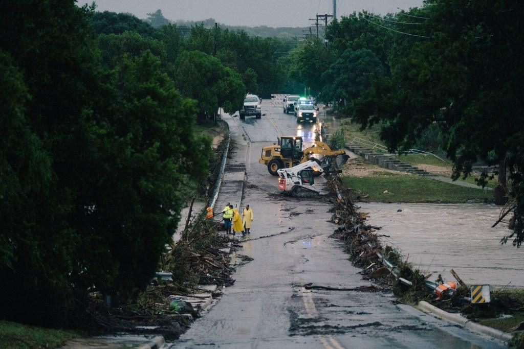
Emergency vehicles navigated debris-laden streets in Center Point on July 16, 2026, where local law enforcement closed bridges for most of the day. The Texas governor highlighted the proactive response triggered by last year’s events during a news conference.
In the wake of last year’s disaster, the Texas Legislature implemented two major reforms: stringent safety regulations for summer youth camps and the installation of warning sirens in areas prone to flash flooding.
The Upper Guadalupe River Authority has since installed six sirens in Kerr County, the site of last year’s most severe damage. While two sirens on the South Fork and one in Hunt were activated, others remained inactive due to their locations in areas experiencing minor flooding. Plans are in place for additional sirens to be installed in the future.
Kerrville Mayor Joe Herring noted that the city collaborated with the county and weather forecasters to disseminate warnings and monitor conditions using a new dashboard that became operational in June, integrating rainfall, river levels, and weather data to assist emergency managers and prepare the community for action.
“That undoubtedly saved lives,” Herring stated on Friday. He highlighted the difference in response capabilities compared to the previous year, stating, “We did not have a warning system in place to gauge the magnitude of the problem heading our way.”
Officials at both the county and city levels were consistently updating their social media channels throughout the night.
In Center Point, volunteer firefighter Razor Dobbs expressed that first responders felt ready this time. The fire department, staffed by trained volunteers 24/7, had acquired new rescue boats, vehicles, specialized equipment, and two trucks. The special operations team was on standby for evacuations as alerts were issued.
“We had been monitoring the situation due to the saturated ground conditions,” Dobbs explained. “As the ground becomes more saturated, it takes less rainfall to trigger flooding.”
Rising waters surged through the area early Thursday morning, with the first alert received by a volunteer around 2:40 a.m. Center Point firefighters responded to numerous distress calls, rescuing individuals from homes, vehicles, trees, and attics. Volunteers Darcy Hasty and Coral Barrett actively knocked on doors to inform residents to evacuate to higher ground.
Dobbs recounted how his team rescued people from floating cars and assisted a man trapped in an 18-wheeler.
The lessons learned from last year’s catastrophe significantly influenced community responses this time, according to Robert Mace, a water expert and executive director of the Meadows Center for Water and the Environment at Texas State University. “People are understandably on edge about these storms and their potential to cause property damage and loss of life,” he remarked.
Rachel Hanes, policy director at the Greater Edwards Aquifer Alliance, noted a heightened level of flood awareness this year, adding that the timing of the event outside a major holiday weekend likely resulted in fewer visitors unfamiliar with local flood risks.
Experts emphasize that each flood event is unique. “The main takeaway is that such occurrences can happen again, and we cannot predict when,” Nielsen-Gammon