







Houston is bracing for another cold front that is set to arrive on Thursday night, bringing a shift in winds and a drop in temperatures. Fortunately, the likelihood of precipitation with this front is minimal, meaning most areas can expect to remain dry without any concerns of ice or sleet.
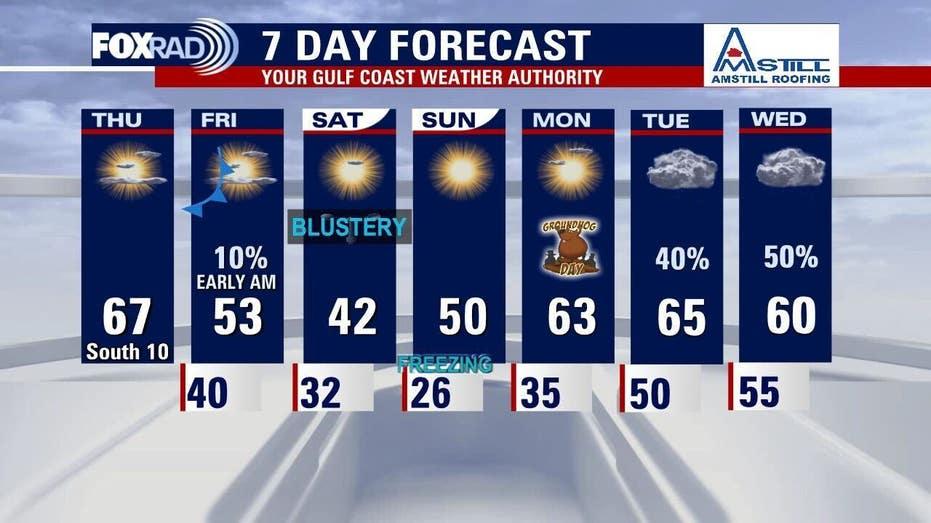
This afternoon is expected to feel quite pleasant, with temperatures rising into the mid to upper 60s under predominantly sunny skies. A breezy south wind will contribute to this mild weather, marking the first afternoon in a week that reaches above normal highs. However, this warm spell will be short-lived as the cold front approaches.
As the cold front moves in tonight, it will usher in a new phase of windy and cooler conditions. Winds will shift to the north, and temperatures are anticipated to start falling on Friday, with a more significant drop expected Friday night.
Looking ahead to the weekend, another blast of arctic air will move into Southeast Texas, leading to a freeze on Saturday morning and potentially a hard freeze, with temperatures dropping below 24°F, on Sunday morning. Saturday is expected to be blustery, with daytime highs struggling to exceed 40°F. However, after a frigid start on Sunday, temperatures may recover to around 50°F by the afternoon, accompanied by sunny skies.
As we look into next week, a gradual warming trend is anticipated as the arctic high pressure system shifts eastward, allowing for a southerly flow to return. By early next week, temperatures are expected to rebound into the low and mid-60s, with a possibility of showers arriving Tuesday or Wednesday.