








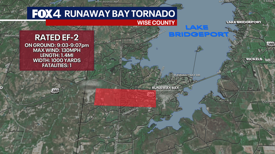
The National Weather Service has officially confirmed that two tornadoes struck North Texas during severe storms over the weekend, one classified as an EF-2 in Wise County and another as an EF-1 in Parker County.
High winds reaching up to 130 mph were recorded, leading to significant destruction, including damaged roofs, destroyed manufactured homes, and numerous downed trees. Survey teams are actively assessing the overall impact, with the potential for revised findings as more information becomes available.
EF-2 Tornado Impacts Wise County
The more powerful EF-2 tornado impacted the Runaway Bay area near Lake Bridgeport, where it was on the ground for approximately four minutes, from 9:03 p.m. to 9:07 p.m., covering a distance of about 1.4 miles. At its peak, the tornado’s width exceeded half a mile, causing extensive damage in residential neighborhoods.
Damage assessments revealed heavy roof destruction, demolished manufactured homes, and significant tree loss. Meteorologists noted the presence of smaller vortices within the tornado, which contributed to localized areas of severe damage. Unusually, this tornado exhibited a westward trajectory, contrasting with the typical northeast movement observed in most tornadoes.
EF-1 Tornado Path and Damage in Parker County
The second tornado, rated EF-1, formed in Parker County west-northwest of Springtown around 9:38 p.m. and traveled nearly 10 miles southeast before dissipating at approximately 10:10 p.m. Its peak winds were estimated at 105 mph.
The damage along this path primarily consisted of downed tree limbs and roof damage, with two homes experiencing significant structural issues, including partial loss of second-story walls.
Enhanced Fujita Scale Overview
The Enhanced Fujita Scale categorizes tornadoes as follows:
- EF-0: 65–85 mph winds
- EF-1: 86–110 mph winds
- EF-2: 111–135 mph winds
- EF-3: 136–165 mph winds
- EF-4: 166–200 mph winds
- EF-5: Over 200 mph winds
NWS Preliminary Findings
The National Weather Service reported that the apparent width of the damage path in Parker County was approximately two-thirds of a mile and may also include areas affected by strong rear-flank downdraft winds ranging from 80 to 90 mph, suggesting that the tornado itself was likely narrower.
These findings from the National Weather Service are preliminary and may be updated as further analysis is conducted.