









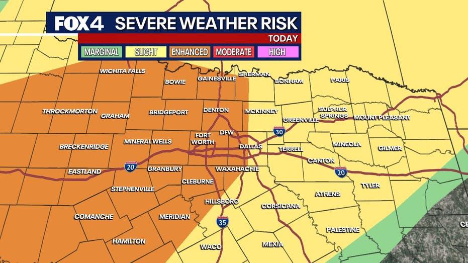
The Dallas-Fort Worth area is bracing for severe thunderstorms, with the most intense activity anticipated between 2 p.m. and 6 p.m. on Tuesday. Storms may persist until 2 a.m. Wednesday, bringing with them the potential for damaging winds, large hail, and localized flooding. While the primary threats are high winds and substantial hail, the possibility of isolated tornadoes cannot be discounted.
Weather forecasts indicate that scattered showers and storms will begin to develop as a dryline approaches from the west. As the day progresses, conditions are expected to worsen, heightening the risk of severe weather.
Forecasters warn that the most significant threats during this event will be damaging winds and hail that could reach up to two inches in diameter. The leading edge of the storm front is likely to be the most severe, with the potential for straight-line winds and brief tornado spin-ups.
The initial wave of storms is projected to sweep through the Metroplex in the afternoon, likely between 2 p.m. and 6 p.m. Though heavy rainfall, lightning, and small hail may accompany these storms, the immediate severe threat remains relatively low.
A more intense second wave of storms is expected to develop during the evening and overnight hours, significantly increasing the likelihood of severe weather, including tornadoes and damaging winds. These storms are anticipated to form as supercells to the west of the Metroplex around 7 p.m. and will merge into a line of thunderstorms, with activity continuing into the early morning hours of Wednesday.
Residents are urged to take shelter immediately if a severe weather warning is issued for their region.
Looking ahead, another round of storms is predicted for Wednesday, primarily from noon to 7 p.m. These storms could produce hail the size of half-dollars and damaging winds. Following this system, North Texas can expect a brief respite with drier and cooler conditions. Sunny skies are forecasted for Thursday, with temperatures reaching the mid-60s, followed by a warm-up into the upper 70s on Friday, leading into a sunny weekend with highs in the low 80s.