North Texas is bracing for a continuation of mid-to-upper 90s temperatures as high pressure remains the dominant weather feature. As the week progresses, low-level moisture is expected to increase, particularly in the eastern regions, bringing back low chances of rain on Thursday and Friday.
Current Weather Conditions
Residents can anticipate temperatures soaring into the mid-to-upper 90s leading into the holiday weekend. Fortunately, these conditions are expected to stay just shy of official heat advisory thresholds. Isolated thunderstorms may develop in the afternoons and evenings throughout the weekend, particularly east of the I-35 corridor. However, the holiday weekend is not expected to be a total washout, as any storm activity will heavily depend on daytime heating and is likely to dissipate after sunset.
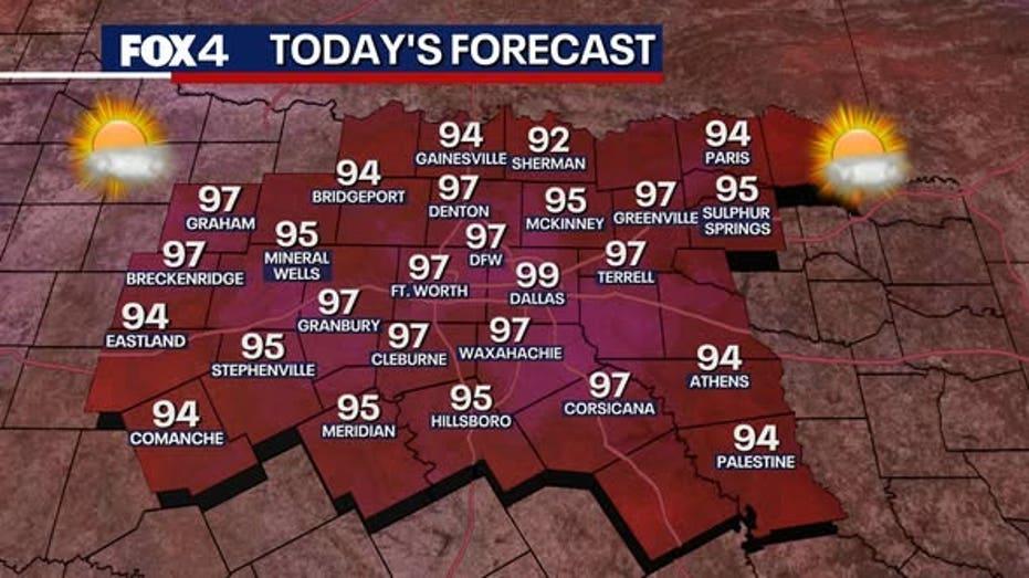
This afternoon, the Dallas-Fort Worth area is predicted to reach a high of 97 degrees, accompanied by breezy conditions with south winds gusting up to 20 mph, creating choppy waters on local lakes. Most of North Texas will experience dry, sunny weather, although there is a slight 10% chance of a stray shower in the far southeastern counties. As night falls, temperatures will drop into the mid-to-upper 70s, with winds beginning to calm down.
Thursday Outlook
Thursday’s forecast is expected to mirror Wednesday’s morning conditions, featuring fair-weather clouds and muggy air. Daytime winds will slightly decrease to 10-15 mph, with high temperatures again peaking in the mid-to-upper 90s. Rain chances will improve slightly, with a 20% likelihood of isolated thunderstorms developing in the afternoon and evening, especially in counties east of Interstate 35.
Fourth of July Weekend Forecast
A dominant high-pressure system will shift to the east and west of the region, allowing weak disturbances from the Gulf Coast to move northward. On Friday, the isolated storm threat will persist, primarily affecting areas east of I-35 in the late afternoon, with high temperatures remaining steady in the 90s.
As Saturday and Sunday approach, the risk of isolated thunderstorms will expand across North Texas, with the most favorable conditions shifting toward the eastern and northeastern areas. Despite the storm potential, the weekend is not expected to be a washout, as any storms that do develop will rely on daytime heating and are projected to dissipate quickly after sunset.